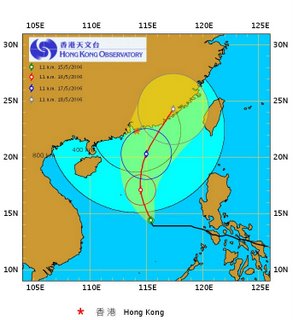
Typhoon warning!*
It has been 10C colder and really dry for a couple of days now – coincidence or can we thank the approaching typhoon? According to the Hong Kong Observatory, Typhoon Canchu is currently about 430km Southeast of Xisha and will come within 800 km of reach from HK tonight. The typhoon is apparently a level 5 storm, which should not be too bad. Well, well….. let’s see what happens!
More info at: http://www.weather.gov.hk/contente.htm
* The terms "hurricane" (North Atlantic Ocean, Northeast Pacific, est of the dateline or South Pacific east of 160E) and "typhoon" (Northwest pacific west of the dateline) are regionally specific names for a strong "tropical cyclone"(upwards of winds of 33 m/s), i.e. a non-frontal synoptic scale low-pressure system over tropical or sub-tropical waters with organized convection (i.e. thunderstorm activity) and definite cyclonic surface wind circulation.
Typhoon CHANCHU at 11:00 HKT 15 May 2006
(14.4 N, 115.4 E)


0 Comments:
Post a Comment
<< Home